Dieses Thema ruht momentan. Die letzte Nachricht liegt mehr als 90 Tage zurück. Du kannst es wieder aufgreifen, indem du eine neue Antwort schreibst.
1dchaikin
Maybe a thread of pictures?

From this link: these rocks rock
Edited to fix link...again - If the link changes again go to http://www.deputy-dog.com and search for "these rocks rock"

From this link: these rocks rock
Edited to fix link...again - If the link changes again go to http://www.deputy-dog.com and search for "these rocks rock"
3DaynaRT
Until I'm able to see this place with my own eyes, I refuse to believe that the Badlands in South Dakota actually exist.

4twomoredays
I am also concerned about that sheep.
As for the Badlands, there's a fascinating article in the most recent issue of National Geographic, fyi.
As for the Badlands, there's a fascinating article in the most recent issue of National Geographic, fyi.
5dchaikin
I trust the sheep, I'm more worried about the tourists who follow.
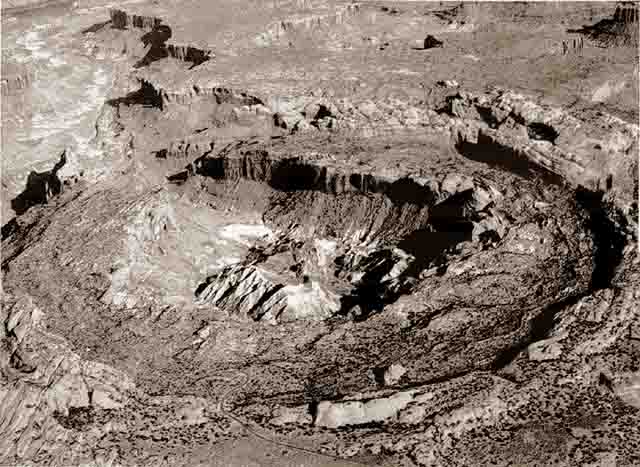
Hope this isn't too obscure. This is from the area of my master's thesis - Guizhou province, China. It's a triassic carbonate bank (think of something like the Bahamas). The entire bank is tilted about 90 deg sideways; top is to the right. The road runs along what is basically a paleo "cliff" that ran along almost the entire length of the picture. (my thesis was on the near-side of the road... yeah, where the little terraced rice paddies are. It's the sand/mud that filled in everything a tiny bit later)

Hope this isn't too obscure. This is from the area of my master's thesis - Guizhou province, China. It's a triassic carbonate bank (think of something like the Bahamas). The entire bank is tilted about 90 deg sideways; top is to the right. The road runs along what is basically a paleo "cliff" that ran along almost the entire length of the picture. (my thesis was on the near-side of the road... yeah, where the little terraced rice paddies are. It's the sand/mud that filled in everything a tiny bit later)

7EncompassedRunner
I really hope that sheep's a photoshop.
8oregonobsessionz
>1 dchaikin:
Great photo! Do you know where that was taken? The rock formations and background topography look like they could be somewhere in the Pacific Northwest, but I am not familiar with this site.
I once climbed a route that had a hanging rock similar to that in your photo, minus the river below. Due to the shape of the surrounding rock wall, you had to climb up under the jammed rock, then find a way to get out and around it without dislodging the thing. Quite a headrush! The real problem came when the lead climber got past the hanging rock. Rope management was essential, to make sure that the rope didn't dislodge the rock and squish climber #2.
I should specify that the climbing route was not especially difficult. The hardest part was overcoming the sense of impending doom while under the rock.
9dchaikin
#8 - I'll pass on climbing either rock.
The pick in #1 is from a fjord in Norway. See the link in #1 (now fixed).
The pick in #1 is from a fjord in Norway. See the link in #1 (now fixed).
10naheim
This is perhaps a little less spectacular than the other pictures posted here, but I think it's pretty cool. It's an algal mound in the Pitkin Formation (Late Mississippian Period) in the Ozarks near Fayetteville, Arkansas. The limestone and shale beds draped over the mound core are loaded with brachiopod fossils.


13oregonobsessionz
Wow, that is gorgeous. I had no idea Kansas had anything that interesting - especially after researchers proved that Kansas is, indeed, flatter than a pancake. This research won an Ig Nobel award in 2003.
14dchaikin
Kansas gets a bad wrap, it has a lot to offer on nature, scenery & geology. You just can't any of it while passing through on I-70.
15naheim
The Monument Rocks are certainly more scenic that the drive across I-70 in Kansas. I also love the cloud formation over the arch. It's quite spectacular!
Here is a double rainbow I was able to catch with my $10 35mm back in 1997. I took the picture in the bad lands of Makoshika State Park in the easternmost part of Montana, near Glendive. The "pots-o-gold" at the end of the rainbows are dinosaur skeletons.

Here is a double rainbow I was able to catch with my $10 35mm back in 1997. I took the picture in the bad lands of Makoshika State Park in the easternmost part of Montana, near Glendive. The "pots-o-gold" at the end of the rainbows are dinosaur skeletons.

17naheim
I recently went backpacking on Cumberland Island on the Georgia Coast and took a couple of Geologically interesting photos. The first is actually from Crooked River State Park near St. Mary's, Georgia, where I camped before taking the ferry over to Cumberland. It shows the immense geological wisdom exhibited by civil engineers who built this road along the marsh. It's a nice example of a cut bank and exposed palosols along the Crooked River. The red hue is from the setting sun.

This picture is of the sand dunes along the Atlantic side of the Cumberland Island. Although it's not apparent in this photo, the dunes on Cumberland are quite wide. Much wider than on Sapelo, which is the other Georgia barrier Island I've visited


This picture is of the sand dunes along the Atlantic side of the Cumberland Island. Although it's not apparent in this photo, the dunes on Cumberland are quite wide. Much wider than on Sapelo, which is the other Georgia barrier Island I've visited

18dchaikin
#17 naheim -- hmm, interesting road.
I just spent a week in the Paradox Basin in Utah. I'm a bit busy, but hopefully I'll post some pictures soon.
I just spent a week in the Paradox Basin in Utah. I'm a bit busy, but hopefully I'll post some pictures soon.
20stretch
Since there are some awesome pics in this topic, I was wondering if you guys would like me to change the profile pic. of the group.
i personally think that the current one is pretty lame in comparison to some of these.
So if ya'll want a change tell me and it will be done. Also, if any of you want to alter the description then shoot me a message.
i personally think that the current one is pretty lame in comparison to some of these.
So if ya'll want a change tell me and it will be done. Also, if any of you want to alter the description then shoot me a message.
21NatureGeek

Aside from the fact that this rock looks like it was drawn by a 7th grade boy, it's really cool because it's basically a fossilized geyser! This is at Kodachrome Basin, southern Utah, and was once basically Yellowstone - the hot spot that is now under Yellowstone was once here, or rather, Kodachrome basin was once over the hot spot. These "sand pipes" were the geyser chambers and vents, filled with sand and solidified with minerals to be harder than the surrounding area, which has since eroded away.
I love the Colorado Plateau!
22NatureGeek

:)
23dchaikin
#21 - Crossbedding in a geyser? I think your are looking at an erosional oddity in one of the eolian sandstones in that part of Utah.
24dchaikin
#20 stretch -- IMO, it's you're call on the front page picture. I like your current choice. I think a constantly changing picture would be cool too, but that's asking too much.
25stretch
dchaikin that is an excellent idea!
I'll change it tonight, but its going to have to remain for awhile. I leaving for field camp in Montana at the end of next week and won't be back till mid-August.
I think after I return I could change the picture every other week or so to give those that visit all that often a chance to glance at new geologic wonder sorta of a rock of the week thing.
On a side note how can you see cross-bedding in that particular portion of the outcrop?
From what I know about the Kodachrome basin is that the presence of these spires of rock, known as sand pipes, are thought to be solidified sediment that filled ancient springs or geysers, left standing after the softer surrounding Entrada sandstone rock weathered away. Not really a "fossilized" Yellowstone but the remains of dormant springs. Differential weather plays an important role in several other spires that have been attributed to fossilized springs in the area but are in fact erosional oddities. Beautiful place to visit.
26dchaikin
#25 Thanks for the explanation, I think I follow now. That is a very strange feature. (It still looks like there is crossbedding to me...)
27ejj1955
I'm about as ignorant regarding geology as it is possible for a human being who once took a basic course in it to be. But these pictures are fascinating and beautiful, so thanks to all of you for posting them!
29NatureGeek
dchaikin:
You know, I am not sure if that particular formation was a sandpipe, like many others I saw up close, so you could very possibly be correct. I've done a lot of exploration of southern Utah and am familiar with many of the formations, but Kodachrome Basin is famous for its sand pipes, and this was right there near the rest, which are fossilized springs. There are certainly lots of spires and other erosional features in the area as well - I just thought it was a fun photo to share! :)
(and you're right, now that I think of it, it does look like cross-bedding... when I took the picture, I wasn't thinking of geology, though, I have to admit - hehe)
30dchaikin
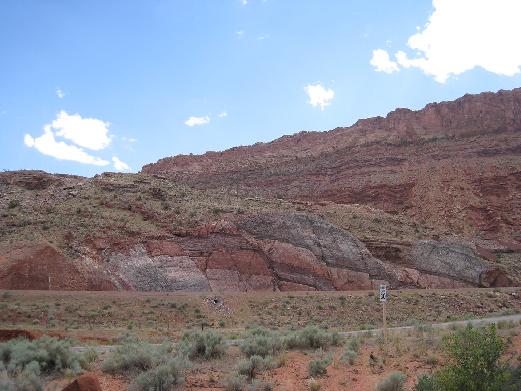
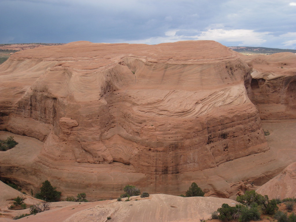
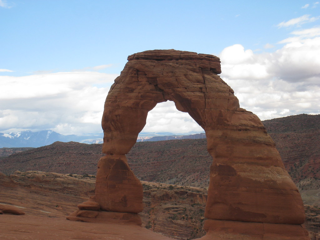
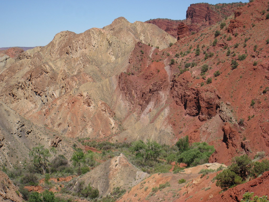
Finally, some pictures from neat Moab, Utah. You can find more on my flickr account here
Faults related to the Moab Fault
 .
.
Navajo Sandstone - Arches National Park
 .
.
Delicate Arch - Arches National Park
 .
.
Edge of a salt dome - at Onion Creek
The white stuff is "Cap Rock" - in this case stuff that is less soluble than salt (mostly gypsum) that caps the buried salt.
Faults related to the Moab Fault
 .
.Navajo Sandstone - Arches National Park
 .
.Delicate Arch - Arches National Park
 .
.Edge of a salt dome - at Onion Creek
The white stuff is "Cap Rock" - in this case stuff that is less soluble than salt (mostly gypsum) that caps the buried salt.

31powderriver
dchaikin
great photos. Did a driveby years ago but couldn't stop. Any picts of Upheval dome? Read several articals of/and about Gene Shoemaker regarding this. A couple of trips went bust so .............. A future trip but $$$ of gas is a bite.
great photos. Did a driveby years ago but couldn't stop. Any picts of Upheval dome? Read several articals of/and about Gene Shoemaker regarding this. A couple of trips went bust so .............. A future trip but $$$ of gas is a bite.
32dchaikin
Powderriver - That is an incredible spot. I do have some pictures, but they are only OK and they aren't on my flickr account (I've filled my quota there for this month). I'll post them here some time in August.
side note: There are two theories for upheaval dome. One is that it's the lower part of an old meteorite impact. The other is that it's the closed neck of a salt diapir (The salt is gone now). Our tour guide is in favor of the salt diapir theory. (edited for accuracy)
side note: There are two theories for upheaval dome. One is that it's the lower part of an old meteorite impact. The other is that it's the closed neck of a salt diapir (The salt is gone now). Our tour guide is in favor of the salt diapir theory. (edited for accuracy)
 .
. .
.34powderriver
you da man! Just got back from a trip to Cape Cod from here in Wyoming. Once again in awe of the earth.
35Helenoel
>25 stretch: Hey stretch, nice new picture on the front page!
37stretch
I know I said I would change the Picture more often.
There's a strange glitch to editing the main picture, I think I have figured it out. At least I hope I have.
I'll change it again in maybe a week or two.
There's a strange glitch to editing the main picture, I think I have figured it out. At least I hope I have.
I'll change it again in maybe a week or two.
38akeela
I’m not a geologist, but a lover of mountains and hiking. I'd like to share this pic taken at Cape Point, the extreme southwestern tip of Africa. I’m sure you guys will have some learned thoughts on the rock formation - for me, it’s simply breathtaking! :)


42Rood
Ummm.. dchaikin, the link at photo #1 isn't working for me. Where might one look?
I'm curious about it, because the photo looks similar to my grandfather's sheep pasture in Norway ... illustrating quite well one of the many reasons he emigrated to the Great Plains of North Dakota.
I'm curious about it, because the photo looks similar to my grandfather's sheep pasture in Norway ... illustrating quite well one of the many reasons he emigrated to the Great Plains of North Dakota.
44subarcticmike
Great pictures, one and all.
I do my 'image-mining' over on flickr(dot)com, saving to My Fav's and keeping an eye on geology groups. Speaking of flickr groups, am I in 'suspect terrain' for future group administrators? such as Thesis Geology, or say Precarious Geology, with the lead-off photo being a certain geo-sheep...
I do my 'image-mining' over on flickr(dot)com, saving to My Fav's and keeping an eye on geology groups. Speaking of flickr groups, am I in 'suspect terrain' for future group administrators? such as Thesis Geology, or say Precarious Geology, with the lead-off photo being a certain geo-sheep...
45Rood
Recently a local Physician, Geologist, Photographer, Pilot, Author, and Humanitarian (among other things) lectured at the Phoenix Public Library on his work with aerial photography and geology, a lecture illustrated by hundreds of spectacular photos taken from around the country. His name is Michael Collier, and though he has published books of his photographs, you can see a small part of his work here:
http://www.npr.org/programs/morning/features/2007/may/aerialphoto/slideshow/inde...
We, of course, had the advantage of having the photos blown up to wall-size, which made it a jaw-dropping experience. After returning that night to his home in Flagstaff, Arizona, Collier was scheduled to leave for Point Barrow, Alaska, where he was scheduled to photograph the dilemma of Polar Bears, who must attempt to live on ever diminishing amounts of Arctic Ocean ice in a time of Global Warming.
46dchaikin
Hi Rood, Collier takes some amazing geology-focused landscape photos. I discovered him last year thanks to someone here on LT. Thanks for the link.
A sample:

A sample:

47stretch
A link to some great pictures of an undersea voclanic eruption off the coast of Tonga.
http://www.boston.com/bigpicture/2009/03/undersea_eruptions_near_tonga.html
http://www.boston.com/bigpicture/2009/03/undersea_eruptions_near_tonga.html
49ejj1955
>47 stretch: Ditto, wow. But the crazies came out of the woodwork to make comments there, didn't they?
50stretch
Oh my, I didn't catch the comments section. I would say we have failed to get the message across thats for sure.
51Helcura
>47 stretch:
Cool. The images make me think of ice structures I've seen, with the dark and light contrasts and the shapes.
Cool. The images make me think of ice structures I've seen, with the dark and light contrasts and the shapes.
52NorthernStar
Diese Nachricht wurde vom Autor gelöscht.

54dchaikin
Hi Northernstar - Can you tell us what we're looking at?
ps - Sadly, it looks like a lot of pictures have gone away. And, elsewhere, the formatting has stopped working. My pictures in post #30 weren't that big when I originally posted.
ps - Sadly, it looks like a lot of pictures have gone away. And, elsewhere, the formatting has stopped working. My pictures in post #30 weren't that big when I originally posted.
55NorthernStar
It's an ichthyosaur - visible remains of this one measure about 8.7m. You can see quite a bit of the spine and ribs. Found some pretty interesting stuff here while on a backcountry paddling trip, so we went back with paleontologists.
56dchaikin
Wow! Ok, I think I can see the spine curving up to the left, and what looks like ribs crisscrossing near the top. I can't make out that piece (or pieces) in the foreground. What part of the world is this?
57NorthernStar
The spine curves around from the middle right across the front to the upper left where the overlying layers come down. Some of the individual vertebrae show up fairly well on the left. The head, which is missing, would have been out of the picture to the upper right. There are some ribs lying along the vertebrae and some very large ones scattered above it. It is in northern BC.
58stretch
Formatting pictures has been odd for a couple of months now. I still can't change the main profile picture. It really is a shame.
59subarcticmike
Hi NorthernStar
oooya, way to go.
Very nice pix with differentiation of bone vs rock.
Are the paleo's relating this "ichthy" to the ones in the news few years back? As found along the Hay River, NWT, just north of the Alberta border. The Hay River material was moderate brown bone on moderate brown matrix. And one of their's was pregnant, all from viewing articles published by U of A. I was nae' so fortunate with my paddling...
60NorthernStar
This location is UTriassic, the Hay River fossils were Cretaceous. Possibly related to Sikanni ichthy. It was a very cool trip. I expect we'll go back.
61stretch
Sweet, I finally figured out the group photo glitch (only took two months!)
Now, I will be changing the photo once a week (with the off week or two) as promised.
Now, I will be changing the photo once a week (with the off week or two) as promised.
62NorthernStar
Nice group picture stretch - where's the delta?
64antisyzygy
If anyone's personal collection needs supplementing the British Geological Survey has just opened up a whole lot of their data including their image archive GeoScenic
66geophile
Doesn't quite fit the category, as it's not a still picture, but cool, all the same:
http://www.youtube.com/watch?v=Tewh2aBaf8U&feature=related
A video made by the Icelandic coast guard of the volcano eruption near Eyjafjallajökull glacier, in South Iceland. The eruption started shortly before midnight on Saturday 20th of March 2010.
http://www.youtube.com/watch?v=Tewh2aBaf8U&feature=related
A video made by the Icelandic coast guard of the volcano eruption near Eyjafjallajökull glacier, in South Iceland. The eruption started shortly before midnight on Saturday 20th of March 2010.
67fatboy2010
i really like yel pics
68NorthernStar
Had to share this - I was on the trip where this was collected:

http://www.facebook.com/home.php#!/photo.php?fbid=498084105171

http://www.facebook.com/home.php#!/photo.php?fbid=498084105171

